GPS-Tracking for Travelling: Recording and Publishing Tours
Memories of travels are very important. In addition to photos, diaries and souvenirs, it is also the documentation of the travelled route which revives our memories. If you had to draw a line in a printed map in the past, there is now the possibility to automatically record the path with GPS-Tracking digitally.
Why A GPS-tracking is worth it, how to do it without being too complicated and time consuming, what opportunities there are and what we have decided for – all that we discuss in this post.
Why is it Worth to Track GPS-Routes?
Recording the GPS-route of a journey has many advantages. When you’re on a longer travel, you easily forget about the details of the track. With GPS-tracking, you have a fancy overview after the tour and therfore a permanent memory of all stations. It is also nice that you can share your route with others, for example, to give recommendations on planning. For us, it is very practical to share our tour live with friends, family and all other blog-readers. A third advantage is the possibility to geotag photos. With a GPS-tracking, photos from any digital camera can be located by fully automatized meta data . The photos can then be displayed on a world map. This helps to keep the overview of all your photos.
The maps module of Adobe Lightroom offers a GPS-track import function.
These are reasons enough to deal with GPS-tracking, it’s challenges, and different approaches.
The Challenges of GPS-Tracking
We would like to start with our first attempt to record the route by GPS on our tour through the Southeast of Europe. It’s a good example that illustrates the problems with tracking.
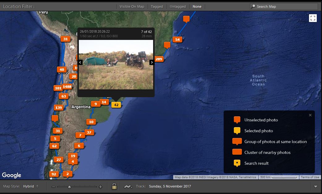
We used the Android App Geo Tracker, the memory function of the Navigon EUROPE App* and the built-in GPS-tracking function of our camera as tools. The aim was to transmit our track to our readers as soon as possible. For the blogging software WordPress, the technical underground of our homepage, there are countless plugins to integrate GPS-data. We tried different and found out that most of them take a lot of effort to configure. Moreover, it was necessary to upload the tracking data manually. During our journey, we noticed that it is too annoying to maintain the tracking data in the blog while we are on the road. File formats had to be converted and the data had to be uploaded manually into special directories on our server. Finally, we used Google My Maps to present our track which we could only maintain after the journey with extremely high effort. Nicki worked for hours to convert and upload data from camera, Navigon and Geo Tracker. The result can be seen here. During our tour, we couldn’t offer any GPS information at all.
A further disadvantage in this method was the dependence of smartphone and camera batteries. For our current great journey, we wanted to use a more effective solution.
Idea 1: TrackMe and Trackserver
After a long research, we found the WordPress Plugin Trackserver. It offers an interface for an automatic upload of GPS-data to your own web server. Within WordPress, it shows a little map on your blog. The free Android GPS-app Trackme can be used to upload the GPS-data in collabaration with Trackserver quite easily. The installation is uncomplicated and you don’t have to maintain GPS-tracks manually. Only a loaded smartphone battery and internet connection are neccesary.
Advantages and Disadvantages
+ cost-effective
+ data are on your own server
+ low effort to set up
+ no additional device is required
– discharges the smartphone battery
– if the battery is empty, it can’t be tracked
– an internet connection is needed to upload data
Idee 2: Spot and Spotwalla
We do not only use the Spot for tracking our tours with the motorbike but also while hiking.
A device which is frequently used by motorcycle travellers and extremesportists is the small orange GPS-Messenger Spot Gen 3*. Above all, it has two functions: Recording GPS-routes and sending messages.
GPS-Tracking with Spot
GPS-tracking with the Spot Gen 3 is very uncomplicated. You just turn on the device and press the tracking button. The device starts blinking, records the route and transfs it to the world without an internet connection. In the tracking options, you can set up different time intervals. Per interval, a position date is loaded to the server. The shorter the time interval, the more accurate the route is, but the higher the battery consumption. You have to consider how detailed you want to record the route and how often you want to change the batteries. We set up a 30-minute interval. Although not every single curve is recorded while riding, we still have a detailed overview of our complete route. Clear advantage: the Spot batteries lasted half a year that way! Our current route recorded with the Spot can be seen here.
Spot stores the route for seven days. You can publish it with or without a password.
Seven days is really not long. Since older data will be mercilessly deleted, the platform Spotwalla offers a better solution. If you connect Spotwalla with your Spot, the route will be saved for a long period of time. In addition, you can get a more customizable map at Spotwalla. For example, the individual tracking points can be connected to a line and you can change the marker on the map to a motorcycle icon. You can also choose to display your routes with Spotwalla for certain periods or just the last seven days.
A very detailed guide for the setup of Spot, Spotwalla and the integration on a website is available at moto.phil’s website.
| Small note: since the European data protection basic regulation has been introduced, there is legal uncertainty about the benefits of iframes, the technique that is included in the blog. We do not want to have a live map in the blog therfore. Instead, we link Spotwalla on our home page via a screenshot of the current route. We replace this screenshot at regular intervals. |
Communication
Since the spot is not only a GPS-tracker but also a communication device, it offers further useful functions beside GPS-tracking. One is, that you can call an international emergency S.O.S. call with a simple touch on a button. This will then be sent to the international organisation GEOS which can inform emergency services worldwide. I hope, we will never have to use it.
In addition, short messages to friends and family can be sent by SMS or E-Mail. Since the Spot has no display, you have to configure phone numbers, E-Mail addresses and messages in advance on a computer with internet connection. You cannot receive answers with Spot.
Advantages and Disadvantages
+ no internet connection is needed
+ automatical “live” tracking
+ battery lasts very long
+ uncomplicated setup
+ small, light and robust
(+ worldwide S.O.S. call)
(+ worldwide sending of E-Mails and SMS)
– much more expensive than the smartphone solution
– the data are on a foreign server
(- unidirectional communication: messages cannot be received)
(-messages and recipients must be defined in advance on the computer)
The points in brackets are not directly comparable to the smartphone solution due to the conceptual difference.
More info on Spot Gen 3 Messenger and technical data is available at WeSPOT.
3. Alternative: Garmin InReach
A device with similar functionality is the Garmin InReach. It is bigger than the Spot and has a display. With the screen, it is possible to lead a multi-channel communication, so messages can be received and answered via the device. You can also perform GPS-navigation. We don’t have any experience with the InReach, so we cannot write a detailed comparism. To receive messages is certainly a great advantage. However, I strongly assume that the display is at the expense of weight, size and above all battery. Moreover, the InReach is much more expensive.
Our Choice
We want to have a reliable GPS-tracking to share our route with our family, friends and blog readers. We have to recharge smartphone batteries very often in everyday life on the road, and internet is not always available. That’s why we’ve decided against the android solution. In addition, the Spot offers the possibility to send an S.O.S. signal in case of emergency. We do not need a display like the Garmin InReach has, because we use our smartphones for navigation and communication anyways. All these reasons lead to our decision for the spot.
| Since we found the Spot on our research for the ideal GPS-tracker before we went on our journey, we send an application for a sponsorship to the company WeSPOT Gbr, which distributes the Spot in Germany, Austria and Switzerland. Fortunately, they agreed and we got the Spot Gen3 Messenger* and a two-year subscription for our trip. The company WeSPOT Gbr is in no way involved in the content of this blogpost. |
All links marked with * are so-called affiliate links. If you order a product over these links, we’ll get a commission. However, it will not be more expensive for you.
If you would like to treat us with something for the 234567 hours of work, because you enjoy our stories: You can give us a roll if you like (guaranteed not to be spent on rolls but on beer).
Once

0 Comments